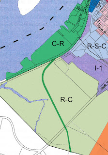
This request is spurred by several recent events or inquiries: a request was made to the City and forwarded to my office from a member of the public--Timothy O'Connor on behalf of the South Bay Coalition--asking for such a determination; a member of the ZBA, Steve Dunn, published a letter and information raising the question of whether the boundaries of the C-R district fully encompassed the "haul road" that is currently the subject of Planning Board review; and a letter dated September 14 from engineers Barton & Loguidice to the Planning Board in relation to the haul road recommended "the Planning Board solicit a formal decision from the appropriate City authority in relation to the zoning district," noting further that "The official Zoning Map appears to show that the proposed haul road may require crossing the Recreational Conservation (R-C) and the Industrial (I-1) Districts."When the ZBA received this request from the mayor, Lisa Kenneally, who chairs the ZBA, told her colleagues, "We can't determine this on our own, but we have the tools to do so," explaining that they would be seeking "information and guidance from the lawyers and engineers." The engineering firm of Barton & Loguidice, who had urged the Planning Board to "solicit a formal decision from the appropriate City authority" regarding the district boundaries, was tasked by the ZBA with assisting in determining the boundaries, and in November 2017, they presented their findings to the ZBA--at a meeting and in a letter. Based on their review of Chapter 325 of the City Code, the 2011 Local Waterfront Revitalization Program (LWRP), the Draft Generic Environmental Impact Statement (DGEIS), the Final Generic Environmental Impact Statement (FGEIS), and the LWRP State Environmental Quality Review Act (SEQRA) Findings Statement (FS), the engineers of Barton & Loguidice concluded:
. . . it appears that the intent of the LWRP and associated zoning amendments was to include the then-proposed South Bay truck route along the causeway and to the Front Street property frontage within the Core Riverfront (C-R) zoning district. The discussion, consideration, and figures within these documents reasonably convey this intent. As shown on the official zoning map of the City of Hudson, the illustration of the C-R district terminating at the railroad tracks as opposed to the Front Street property frontage would appear to be in error.At its last meeting on February 21, it was announced that the ZBA, before it made its official determination, would hold a public hearing on the issue, to allow people to provide additional information relevant to the question of boundaries and to respond to the information and conclusions provided by Barton & Loguidice. That public hearing is scheduled to take place on Wednesday, March 21, at 6:15 p.m.
COPYRIGHT 2018 CAROLE OSTERINK


The conclusion of Barton & Loguidice is precisely what everyone was saying in 2011, even before the amended Zoning Map was adopted into law (everyone aside from the Common Council that is, with one Alderman providing the memorable exception):
ReplyDeletehttp://gossipsofrivertown.blogspot.com/2011/11/wheres-map.html